| Day | Date | Time | LSD | Notes |
|---|---|---|---|---|
| Sat | Jan 6 | |||
| Sun | Jan 7 | 6:30 | Ou Meul, Pinelands | |
| Sat | Jan 13 | Hohenort 15 | ||
| Sun | Jan 14 | 6:30 | The Pantry in Tokai | |
| Sat | Jan 20 | |||
| Sun | Jan 21 | 6:30 | No Run planned | Bay to Bay |
| Sat | Jan 27 | Red Hill Classic/Marathon | ||
| Sun | Jan 28 | 6:30 | Mouille Point Lighthouse | |
| Sat | Feb 3 | Firgrove 15km | ||
| Sun | Feb 4 | 6:30 | Noordhoek - Chappies | |
| Sat | Feb 10 | |||
| Sun | Feb 11 | 6:30 | Fish Hoek Beach - Noordhoek | Milkwood Half |
| Sat | Feb 17 | |||
| Sun | Feb 18 | 6:30 | Ladies Mile Spur - - Wynberg | Peninsula Marathon & Half |
| Sat | Feb 24 | |||
| Sun | Feb 25 | 6:30 | Tafelberg Rd/Kloof Nek | |
| Sat | Mar 2 | Century City 10 | ||
| Sun | Mar 3 | 6:30 | CV 15 + Extra 5kms | CV Helpers Run |
| Sat | Mar 9 | CV 15km race | ||
| Sun | Mar 10 | 6:30 | Ladies Mile Spur - Constantia | Cape Town Cycle Tour |
| Sat | Mar 16 | |||
| Sun | Mar 17 | 5:30 | 40km Two Dogs from Fish Hoek | |
| Sat | Mar 23 | |||
| Sun | Mar 24 | 6:30 | Westlake Golf Course | Tygerberg 30km |
| Sat | Mar 30 | 6:30 | Hout Bay to 2 Oceans Finish | Easter Weekend |
| Sun | Mar 31 | Easter Weekend | ||
| Sat | Apr 6 | |||
| Sun | Apr 7 | 7:00 | Mouille Point | |
| Sat | Apr 13 | No Run planned | Two Oceans Ultra | |
| Sun | Apr 14 | No Run planned | Two Oceans Half | |
| Sat | Apr 20 | Spookhill Challenge | ||
| Sun | Apr 21 | 7:00 | Lion's Circuit | |
| Sat | Apr 27 | Outeniqua Marathon & Half | ||
| Sun | Apr 28 | 7:00 | Tafelberg Rd/Kloof Nek | |
| Sat | May 4 | |||
| Sun | May 5 | 7:00 | Landmarks from Dean Street | |
| Sat | May 11 | |||
| Sun | May 12 | 7:00 | The Pantry in Tokai | ABSA CT 10km Race |
| Sat | May 18 | |||
| Sun | May 19 | 7:00 | Forries - Zoo route | |
| Sat | May 25 | |||
| Sun | May 26 | 7:00 | Apostles - Gardens | Slave Route Challenge |
| Sat | Jun 1 | |||
| Sun | Jun 2 | 7:00 | Ladies Mile Spur - Constantia | |
| Sat | Jun 8 | |||
| Sun | Jun 9 | 7:00 | VOB Clubhouse | Comrades Marathon |
| Sat | Jun 15 | |||
| Sun | Jun 16 | 7:00 | Ou Meul - Pinelands | |
| Sat | Jun 22 | Mamre 21km | ||
| Sun | Jun 23 | 7:00 | Mouille Point Lighthouse | |
| Sat | Jun 29 | |||
| Sun | Jun 30 | 7:00 | Fish Hoek Beach - Noordhoek |

Sparrows - Sunday LSD runners
Planner
The Routes
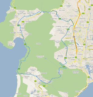
1 Kommetjie - Scarborough:

2 Tokai - Kalk Bay:

3 Noordhoek - Hout Bay:


5 Bergvliet - Kirstenbosch:

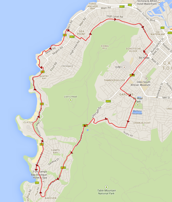
6 Camps Bay - Suikerbossie:

7 Kalk Bay - Simonstown:

8 Tafelberg road - Signal Hill:


11 Zoo Parking Lot:


- Location: Shell garage, Kirsten avenue
- Water: Seconding is required
- GPS: -34.140558,18.329224 OpenStreetMap
- Distance: 22km (with an optional extra 6km: turn at point C)
- Route:

2 Tokai - Kalk Bay:
- Location: Tokai, cnr Tokai and Dalmore roads
- Water: Bring your own
- GPS: -34.06201,18.435262 OpenStreetMap
- Distance: 22km
- Route: Tokai, Pollsmoor, Westlake golf course, Kalk bay and back

3 Noordhoek - Hout Bay:
- Location: Noordhoek farm village (Parking lot off Village lane).
- Water: We drink from the rivers en-route
- GPS: -34.096858,18.37664 OpenStreetMap
- Distance: 20km
- Approximate route:

- Location: Noordhoek farm village (Parking lot off Village lane).
- Water: Seconding required
- GPS: -34.096858,18.37664 OpenStreetMap
- Distance: 19km
- Approximate route:

5 Bergvliet - Kirstenbosch:
- Location: Spur car park, Ladies mile, Bergvliet.
- Water: Bring your own
- GPS: -34.048508,18.454403 OpenStreetMap
- Distance: 19km
- Approximate route:

6 Camps Bay - Suikerbossie:
- Location:
Opposite Camps bay High SchoolOpposite Camps Bay Police Station - Water: Bring your own
- GPS:
-33.944406,18.37752 OpenStreetMap - Distance:
20km18km - Route: Suikerbossie and back

7 Kalk Bay - Simonstown:
- Location: Main Road, Kalk Bay. From Kalk Bay station.
- Water: Bring your own
- GPS: -34.124524,18.45175 OpenStreetMap
- Distance: 25km (or less if you want)
- Route: Kalk Bay to Simons Town Golf club and back (just past Boulders). On the way back, we run along Fish Hoek beech if its low tide.

8 Tafelberg road - Signal Hill:
- Location: Tafelberg road. Meet at the Kloof Nek car-park.
- Water: Bring your own.
- GPS: -33.942995, 18.395618 OpenStreetMap
- Distance: 19km
- Route: Depart from Kloof Nek, run past the cable station to the end of the tar, then we retrace our steps, and go all the way to Signal hill. We then return to the start at Kloof Nek.

- Location: Noordhoek Farm Village
- Water: Seconding is required
- GPS: -34.096824,18.377295 OpenStreetMap
- Distance: 41km (with an optional extra 4km)
- Route:

- Location: At the Light House, Beach Road Mouille Point
- Water: Bring your own
- GPS: -33.901704,18.399621 OpenStreetMap
- Distance: 22km
- Route:

11 Zoo Parking Lot:
- Location:
At the entrance gate of Rhodes MemorialThe parking lot facing the exit from UCT, 500m closer to UCT from where we used to park. This new meeting place is opposite the security hut at the booms at the South Exit from UCT. It's right next to where we used to park - just closer to UCT (and much bigger and hopefully safer). Don't take the Rhodes Memorial exit from the M3, but rather the 'UCT' exit. (Assuming you're coming from Constantia side, this is the exit after the Rhodes Memorial turn-off.) - Water: Bring your own
- GPS: -33.961061,18.459785 OpenStreetMap
- Distance: 20km
- Route:

- Location: Parking lot at the entrance of Ruyterplaats Estate Near Suikerbossie Restaurant
- Water: Bring your own
- GPS: -34.0124,18.351105 OpenStreetMap
- Distance: 19km
- Route: Camps Bay and back

- Location: Parking lot at Fruit & Veg City, Tokai
- Water: Bring your own
- GPS: -34.062775,18.458979 OpenStreetMap
- Distance: 20km
- Route: To Kalk Bay via Sandvlei and Muizenberg, then back via Boys drive or Main road.

- Location: Westlake business park, outside SA National Parks offices on Westlake drive (50m from the traffic lights at the intersection with Steenberg road.)
- Water: Bring your own
- GPS: -34.080376,18.439774 OpenStreetMap
- Distance: 26 or 30km
- Route: Boyes drive, Kalk Bay, (optionally Blackhill,) Sun Valley, Oukaapse Weg. The short option cuts out Blackhill, and goes directly from Fish Hoek to Sun Valley.

- Location: At the Light House, Beach Road Mouille Point
- Water: Bring your own
- GPS: -33.901704,18.399621 OpenStreetMap
- Distance: 18km
- Route: A loop around Lion's Head taking in some nice views and lots of variety. Contains some sections on jeep track.

16 Constantia route from VOB:


- Location: Meet outside the VOB clubhouse.
- Water: Bring your own
- GPS: -34.019532,18.447814 OpenStreetMap
- Distance: 22km
- Route: A loop through Upper Wynberg, past Monterey, through upper Constantia, and back to the clubhouse via Groot Constantia and Klein Constantia.

- Location: Meet at the VOB clubhouse in Constantia
- Water: Bring your own
- GPS: -34.019532,18.447814 OpenStreetMap
- Distance: 22km
- Route: From Signal hill, along Tafelberg road, the contour path, left down to Rhodes Memorial, Union Avenue, Paradise Motors, Tenant Road, Wolfe Street Wynberg Hill, to the Club House..

- Location: Camps Bay tidal pool / police station
- Water: Bring your own
- GPS: -33.955286,18.376549 OpenStreetMap
- Distance: 19km
- Route: From Camps Bay we run along main road into Sea Point. Near to the swimming pools, we run up to Ocean View drive and follow it to Buitengragt and then on to Camp street in Gardens. Once in Gardens we proceed through Higgovale to Kloof Nek, and then down through Camps Bay to the start.
- Location: Mariner's Wharf.
- Water: Bring your own
- GPS: -34.046962, 18.348208 OpenStreetMap
- Distance: 21km
- Route: From "Mariner's Wharf" we run up towards "Suikerbossie", and from there through Ruyterplaats Estate to World of Birds and then down Valley road. Once back on Victoria road, we go to Hout Bay main road and follow it about half way up the hill to Chapmans Peak. The turning point is a waterfall where we stop for water. We then take the shortest route back to the start.
- Location: Noordhoek Farm Village.
- Water: Seconding required
- GPS: -34.080376,18.439774 OpenStreetMap
- Distance: 29km
- Route: From Noordhoek Farm Village, over Ou Kaapse Weg, along Spaanschemat, up Ladies Mile, Parish, Southern Cross, Rhodes Drive, Rhodes Avenue and ending at the gate to Rhodes Memorial just before UCT.
- Important Note: This is not an out-and-back route. We will initially meet at the finish, and then share lifts to the start in as few cars as possible. i.e. Don't just go to the start - you might not get a lift back to your car!
21 Fish Hoek - Glencairn:
- Location: Fish Hoek beach corner.
- Water: Bring your own
- GPS: -34.140706, 18.431885 OpenStreetMap
- Distance: 20km
- Route: From the parking lot near to the rocks at the end of Fish Hoek beach, we run along main road towards Sun Valley and Kommetjie, bearing left. At the 4-way intersection with the Glencairn expressway we turn left and head over to Glencairn. From Main road Glencairn, we turn right into the Glencairn valley, and follow the road in a circular loop up to Da Gama park and down through Dido Valley to Main road where we turn left and return to Fish Hoek beach via the catwalk, ending the run with an optional swim and ice cream.

22 Fish Hoek - Muizenberg:
- Location: Fish Hoek beach corner.
- Water: Bring your own
- GPS: -34.140706, 18.431885 OpenStreetMap
- Distance: 20km
- Route: From the parking lot near to the rocks at the end of Fish Hoek beach, we run towards Muizenberg (on the beach if the tide is low and the sand firm). We follow Main road to St James where we proceed along the cat-walk. Once in Muizenberg, we run along the canal and Sand Vlei, crossing the railway line at the Lakeside station bridge. We then continue along Main road, returning via Boyes drive, ending the run with an optional swim and ice cream.

- Location: Fish Hoek beach corner
- Water: Seconding is required
- GPS: -34.14074, 18.43185 OpenStreetMap
- Distance: 48km (or 42 if you stop in Muizenberg)
- Route:

24 Fish Hoek - Clovelly - Monkey Valley:
- Location: Fish Hoek beach corner.
- Water: Bring your own
- GPS: -34.140706, 18.431885 OpenStreetMap
- Distance: 21km
- Route: From the parking lot near to the rocks at the end of Fish Hoek beach, we run towards Muizenberg (on the beach if the tide is low and the sand firm). We turn left at Clovelly and follow the jeep track above the golf course all the way to Sillvermine, continuing on to Noordhoek where we meander through Monkey valley, and finally retrace our steps back.

25 Landmarks from Dean Street Newlands:
- Location: Dean street Newlands, intersecting Main street.
- Water: Bring your own
- GPS: -33.97105, 18.46398 OpenStreetMap
- Distance: 21km
- Route: The route follows the route of the Landmarks Half marathon (approximately) but starts in Dean Street in Newlands at the circle where it intersects with Main street.

26 Westlake Golf Course to Kalk Bay:
- Location: Westlake Golf Course parking lot.
- Water: Bring your own
- GPS: -34.0834268, 18.4432253 OpenStreetMap
- Distance: 18km
- Route: From Westlake Golf course we run towards Muzenberg, crossing the railway line at Sandvlei where we loop around Muizenberg High. We then follow the coastline as far as Kalk Bay where we turn up Boyes drive to return to the golf course.

- Location: Start at the Light House in Mouille Point.
- Water: Bring your own
- GPS: -33.9016, 18.4002 OpenStreetMap
- Distance: 20km
- Route: This route follows an approximate route of the well known 'Slave Route' half marathon, however it starts and ends in Mouille Point, and does not go through the Castle.

Subscribe to:
Posts (Atom)